
Lesson overview
A practical ratio skill for maps, plans, models and diagrams.
Scale drawings use proportion to represent large or small real objects on paper. The main skill is keeping the scale factor and units clear.
What you will learn
Key facts before you start
Scale drawings and map scales infographic
Before viewing
Before viewing, identify the drawing length, real length and scale relationship.
After viewing
After viewing, convert one map distance into a real distance with units.
Why this matters
Maps, floor plans, construction drawings, model designs and route diagrams all use scales. A small measurement on a page can represent a much larger real distance.
Scale questions are often straightforward once the units are tidy. Most mistakes come from mixing cm, m and km.
Prior knowledge
You should already be comfortable with:
Clear explanation
What a scale means
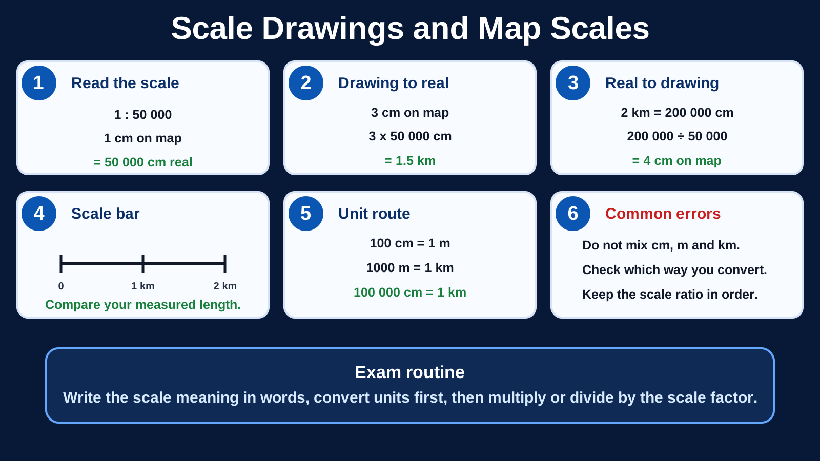
A scale compares a length on a drawing with the matching real length. The scale 1 : 50 000 means:
So, on a 1 : 50 000 map, each 1 cm represents 0.5 km.
A scale in the form 1 : n compares matching lengths in the same unit. It does not mean 1 cm must be used, but cm is often the easiest unit for maps and plans because ruler measurements are in cm.
Map length to real distance
Multiply the map length by the scale factor, then convert units if needed.
6 cm on a 1 : 50 000 map 6 × 50 000 = 300 000 cm 300 000 cm = 3000 m = 3 kmReal distance to drawing length
Work in matching units first, then divide by the scale factor.
A real distance is 2 km 2 km = 200 000 cm 200 000 ÷ 50 000 = 4 cm on the mapUsing a scale bar
A scale bar gives a direct comparison. If a 2 cm bar represents 1 km, then 1 cm represents 0.5 km.
If 2 cm represents 1 km, then a 6 cm route represents 3 km.
Length scale is not area scale
If a question asks for an area on a plan, scale the lengths first and then multiply the scaled lengths. Do not multiply an area by the length scale once.
Worked examples
Example 1: Map distance to real distance
A map has scale 1 : 25 000. Two towns are 8 cm apart on the map. Find the real distance in km.
8 × 25 000 = 200 000 cm 200 000 cm = 2000 m = 2 kmReveal answer
Answer: 2 km.
Example 2: Real distance to drawing length
A scale drawing uses scale 1 : 200. A real wall is 9 m long. How long should it be on the drawing?
9 m = 900 cm 900 ÷ 200 = 4.5 cmReveal answer
Answer: 4.5 cm.
Example 3: Using a scale bar
On a map, a 3 cm scale bar represents 12 km. A route measures 7.5 cm. Find the real route distance.
1 cm represents 12 ÷ 3 = 4 km 7.5 cm represents 7.5 × 4 = 30 kmReveal answer
Answer: 30 km.
Example 4: Choosing the right direction
A model car is built at scale 1 : 18. The model is 24 cm long. Find the real car length in metres.
24 × 18 = 432 cm 432 cm = 4.32 mReveal answer
Answer: 4.32 m.
Example 5: Plan area from scaled lengths
A patio is 6 m by 4 m. It is drawn at scale 1 : 100. Find the patio area on the plan in cm².
6 m = 600 cm, so plan length = 600 ÷ 100 = 6 cm 4 m = 400 cm, so plan width = 400 ÷ 100 = 4 cm plan area = 6 × 4 = 24 cm²Reveal answer
Answer: 24 cm².
Quick checks
Choose an answer, then check your thinking.
1. A scale is 1 : 100. A drawing length is 6 cm. What is the real length?
2. On a 1 : 50 000 map, 1 cm represents what real distance?
3. A real length is 12 m. The scale is 1 : 300. What is the drawing length?
Practice questions
Question 1
A map has scale 1 : 10 000. A path is 12 cm long on the map. Find the real length in metres.
Reveal answer and marking guidance
Answer: 1200 m.
Marking: 12 × 10 000 = 120 000 cm; 120 000 cm = 1200 m.
Question 2
A room is 5.6 m long. A plan uses scale 1 : 80. Find the plan length in cm.
Reveal answer and marking guidance
Answer: 7 cm.
Marking: 5.6 m = 560 cm; 560 ÷ 80 = 7 cm.
Question 3
On a map, 4 cm represents 10 km. A route measures 9 cm. Find the real distance.
Reveal answer and marking guidance
Answer: 22.5 km.
Marking: 1 cm represents 10 ÷ 4 = 2.5 km; 9 × 2.5 = 22.5 km.
Question 4
A model uses scale 1 : 75. A real tower is 18 m tall. Find the model height in cm.
Reveal answer and marking guidance
Answer: 24 cm.
Marking: 18 m = 1800 cm; 1800 ÷ 75 = 24 cm.
Question 5
A map scale is 1 : 40 000. Two points are 6.5 cm apart on the map. Find the real distance in km.
Reveal answer and marking guidance
Answer: 2.6 km.
Marking: 6.5 × 40 000 = 260 000 cm; 260 000 cm = 2600 m = 2.6 km.
Question 6
A drawing length is 3.2 cm and the real length is 8 m. Find the scale in the form 1 : n.
Reveal answer and marking guidance
Answer: 1 : 250.
Marking: 8 m = 800 cm; 800 ÷ 3.2 = 250, so the scale is 1 : 250.
Question 7
A plan of a classroom uses scale 1 : 50. A desk is 2.4 cm long on the plan. Find the real desk length in metres.
Reveal answer and marking guidance
Answer: 1.2 m.
Marking: 2.4 × 50 = 120 cm, and 120 cm = 1.2 m.
Question 8
A map has scale 1 : 25 000. A walking route is 3.6 km in real life. Find its length on the map in cm.
Reveal answer and marking guidance
Answer: 14.4 cm.
Marking: 3.6 km = 360 000 cm. Then 360 000 ÷ 25 000 = 14.4 cm on the map.
Question 9
A rectangular playground is 4.8 cm by 3.5 cm on a plan. The scale is 1 : 250. Find the real area of the playground in m².
Reveal answer and marking guidance
Answer: 105 m².
Marking: Scale the lengths first: 4.8 × 250 = 1200 cm = 12 m and 3.5 × 250 = 875 cm = 8.75 m. Then area = 12 × 8.75 = 105 m².
Question 10
A scale drawing of a garden uses scale 1 : 60. The patio is 7.5 cm by 4 cm on the drawing. Find the real perimeter of the patio in metres.
Reveal answer and marking guidance
Answer: 13.8 m.
Marking: Scale the lengths first: 7.5 × 60 = 450 cm = 4.5 m and 4 × 60 = 240 cm = 2.4 m. Perimeter = 2(4.5 + 2.4) = 13.8 m.
Answers and marking guidance
The exact practice answers are hidden under each question so you can try first. For scale drawings and maps, marks usually come from converting both measurements into compatible units, applying the scale factor in the correct direction, labelling drawing and real distances clearly, and checking whether the final answer should be in cm, m or km. When a question asks for the scale itself, compare matching lengths in the same unit before simplifying to 1 : n. For plan-area questions, scale the lengths first and then calculate the area.
Common mistakes
- Mixing units: convert real lengths into the same unit as the drawing before dividing.
- Multiplying when you should divide: map to real usually multiplies; real to map usually divides.
- Forgetting that 100 000 cm = 1 km: this is useful for map scales.
- Measuring carelessly: small ruler errors can create large real-distance errors.
- Leaving impossible units: a real town-to-town distance should usually be in km, not cm.
- Scaling area like a length: if the task asks for area, convert the side lengths on the drawing first, then multiply them.
Extension challenge
A rectangular garden is 14 m by 9 m. It is drawn on a plan at scale 1 : 200. Find the area of the rectangle on the plan in cm².
Reveal answer
Answer: 31.5 cm².
14 m = 1400 cm, so plan length = 1400 ÷ 200 = 7 cm. 9 m = 900 cm, so plan width = 900 ÷ 200 = 4.5 cm. Plan area = 7 × 4.5 = 31.5 cm².
Exam-board guidance
Scale drawings and map scales are common across GCSE Maths. Expect questions involving ratio, proportional reasoning, metric conversions, plans, maps and real-life measurements.
AQA GCSE Maths
Focus on the shared method, notation and checking habit; wording and context can vary by route.
OCR GCSE Maths
Show clear method steps and use precise notation; question wording may vary by route.
Pearson Edexcel GCSE Maths
Keep working visible and check units or notation; contexts may vary by route.
Eduqas GCSE Maths
Use the same core skill in practical contexts, with clear reasoning and final checks.
WJEC Wales
Connect the method to the context and state what the result means.
CCEA GCSE Maths
Make each method step visible and keep notation, units and final checks clear.
Next lesson
Next, build on rates and units with Compound Measures: Speed, Density and Pressure.